Quebec municipalities brace for new flood zone maps that show more properties at risk

Posted December 15, 2024 6:00 am.
Last Updated December 15, 2024 11:21 am.
MONTREAL — Officials in some Quebec municipalities ravaged by past flooding say they fear possible financial repercussions for residents as the province prepares to introduce new flood maps that would greatly expand areas deemed at risk.
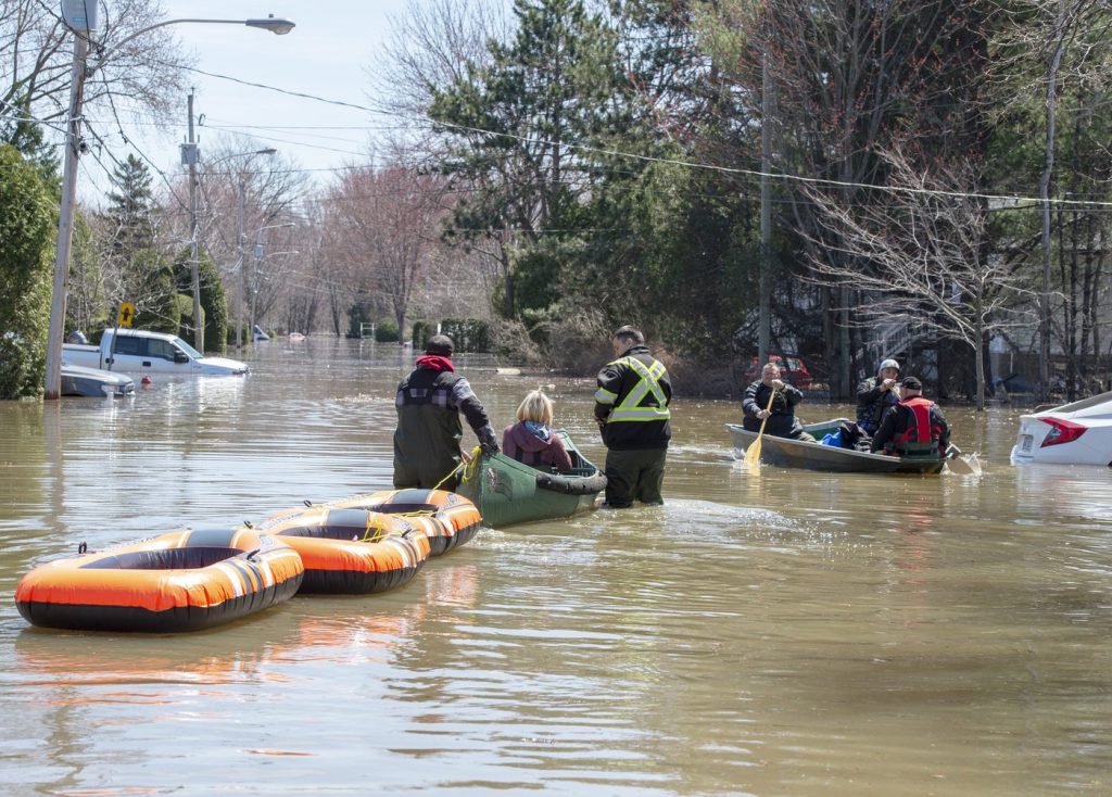
Five years ago, when a dike gave way in Ste-Marthe-sur-le-Lac, Que., the rush of water forced more than 6,000 people from their homes. Residents have since struggled to rebuild their lives in the town just west of Montreal, but Mayor François Robillard says the new flood zone maps are sparking more frustration.
“Citizens are really shocked right now …. because it’s going to have an effect on their daily lives,” he said in an interview.
Quebec’s current flood maps designate two risk zones for river and coastal areas — flooding is expected either within 20 years or somewhere between 20 and 100 years. Under the new system expected to be rolled out in 2025, there will be four categories of risk: low, moderate, high and very high. Each category has its own rules regarding construction and renovation.
For instance, a property owner in a very high-risk area would not be allowed to build a new house on the property or rebuild a house that had been destroyed by flooding.
Robillard says the preliminary maps he has seen put 2,000 of his town’s homes in flood zones, up from just two now. The drastic shift has residents in his town of about 20,000 residents scrambling to understand the impact such designations will have on their properties.
“In 2019, the dike broke and there was a flood, so from that moment the government authorized everyone, all the people in Ste-Marthe-sur-le-Lac who were affected, to rebuild without the restrictions of a flood zone,” he said. With a new dike in place, residents thought they were safe.
“If they’d known that four-and-a-half years later that we were going to declare a flood zone … people wouldn’t necessarily have invested here,” Robillard said. “They might have taken the government’s money and reinvested it elsewhere,” he said, calling the government’s change of course “nonsense.”
The Quebec Environment Department did not respond to a request for comment.
In June, the department estimated that under the new maps, more than three times as many Quebecers would find themselves living in at-risk zones — from the current 22,000 homes to 77,000. Then, last month, the department said the figure would likely be revised downward.
Just west of Ste-Marthe-sur-le-Lac on Lake of Two Mountains, Pointe-Calumet is also protected by a dike. It has not flooded since the 1970s and Mayor Sonia Fontaine says it has not previously been considered a flood zone. However, the updated flood maps would put over 97 per cent of the territory in a flood zone, she said.
Fontaine accused the province of leaving people in the dark and fearful that their property values are about to drop.
“Since June, people don’t know what to do with their homes here,” she said, adding that the impact is being felt even before the new maps come into effect. “I meet people every week, people who are crying, people who can’t sell their homes today.”
Both Fontaine and Robillard want the government to remove proposed flood zone designations for their municipalities and create a separate category for municipalities that are protected by dikes.
Frustration over flood maps has taken a darker turn in the lower Laurentians region of the province. Sylvie D’Amours, the Coalition Avenir Québec member for Mirabel, announced in October she was closing her riding office for safety reasons. Someone firing what police described as a pellet gun had shattered a window in the office, and D’Amours suggested anger over her government’s plan to update flood zone maps as a possible motive.
Beauceville, south of Quebec City, has also had its share of floods. In 2019 an ice jam on the Chaudière River burst free, sending water and chunks of ice through the heart of its historic downtown. Some 100 buildings had to be demolished.
Serge Vallée, the town’s general manager, said 59 buildings in Beauceville are currently located in flood zones.
“What we’re afraid of is that it’s going to increase with the new maps,” he said, adding that even a low-risk designation could have a negative effect on their mortgages and insurance.
Joanna Eyquem, who specializes in climate-resilient infrastructure at University of Waterloo’s Intact Centre on Climate Adaptation, said poor communication and a lack of readily accessible information has contributed to the outcry in Quebec.
Quebecers should not be getting such information only from the provincial and municipal governments but also from insurance companies and mortgage providers, which have their own flood zone maps, she said.
However, Eyquem pointed out that dikes can be breached and the risk to towns like Ste-Marthe-sur-le-Lac and Pointe-Calumet shouldn’t be ignored.
Although the new mapping system is a positive step forward, Canada lags far behind such countries as the United States and the United Kingdom in countrywide mapping, she said, adding that the new Quebec maps do not even account for heavy rainfall, which will be an increasing source of flooding due to climate change.
This report by The Canadian Press was first published Dec. 15, 2024.
Joe Bongiorno, The Canadian Press


