Quebec adopts new regulatory framework for flood zones

Posted June 12, 2025 12:22 pm.
Last Updated June 12, 2025 6:03 pm.
The Quebec government announced Thursday the adoption of a modernized regulatory framework surrounding flood zones.
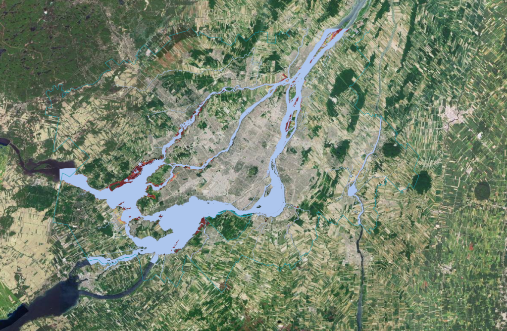
The framework adopted this week will only come into effect in March 2026 and the new maps could expand existing flood zones by about 30 per cent.
“We are currently at approximately 25,000 (housing units located in flood zones) and this number would increase by 30 per cent, which would bring the total to 35,000,” Environment Minister Benoit Charette said at a press conference.
“We are not creating new flood zones, we are simply identifying them,” Minister Charette was keen to point out.
“Given that the maps had not been updated” for “about 30 years,” there are “flood zones that were not identified and yet were clearly in problem areas.”
Flood zones smaller than expected
In June 2024, the Ministry of the Environment estimated that approximately 77,000 residences were located in areas at risk of flooding, according to the new way of mapping flood zones, but this number has since been revised downwards.

Asked why the estimated number of residences located in future flood zones had decreased in recent months, the minister replied: “We’re talking about 30 per cent, but it’s impossible to say exactly how much, because the maps have not yet been made. At the same time, to reassure people, if you are one of those who were not in a flood zone and who will be, you will probably be in an area where the risk is very low.”
These proposed regulations are necessary because of the magnitude of climate change, said the Minister of the Environment.
“With this modernization, we are giving ourselves the means to better protect the population, our property and our territory,” declared Benoit Charette.
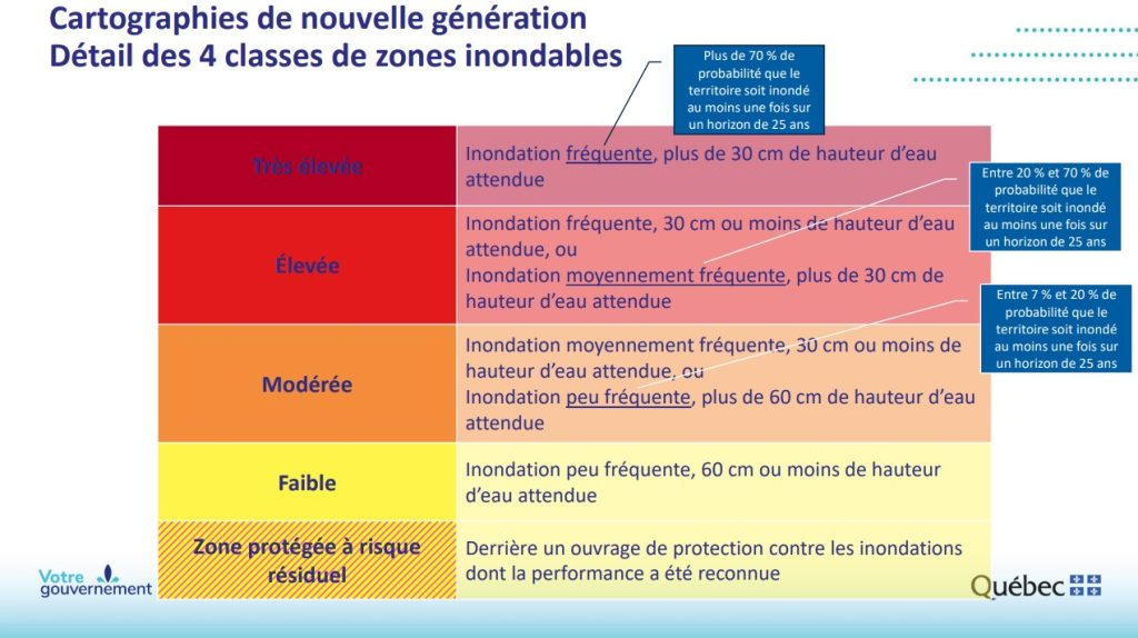
Five zones
Currently, floodplain mapping presents recurrence ratings of “0-20 years” and “20-100 years”, while the new generation of maps proposes a classification with five risk categories: low, moderate, high, very high and protected with residual risk.
Each risk is associated with a color.
The “protected area at residual risk” is a novelty. It concerns areas located behind protective structures and is part of the changes made to the proposed regulation a year ago, following public consultations. Several municipalities wanted to create this zone.
During a technical briefing to the media, a ministry official explained that at the request of municipalities, the government has also made “relaxations” to the criteria for an area to be in the “low” and “moderate” zones, which could explain, in part, why the number of homes in future flood zones has been revised downwards.
There is nothing in the proposed by-law that would require a local resident to relocate.
Modernization of regulatory framework for water environments and supervision of flood protection structures... by CityNewsToronto on Scribd
Each level of risk corresponds to new regulations concerning the construction and renovation of residences that are located in these zones.
For example, in the “very high” zone, which corresponds to a more than 70 per cent risk of being flooded at least once over a 25-year horizon, a homeowner would not be allowed to build a new residence or rebuild a house that has been destroyed.
The owner could make renovations or modifications, such as changing the location of the electrical entrance, or installing bedrooms on the second floor, to make their home more resilient to flooding.
In the “high” and “moderate” zone, disaster reconstruction would be possible under different conditions.
Consultations on flood zone regulations had raised concerns. For example, municipalities criticized Quebec for beginning these consultations too quickly, without informing residents who were located in the new flood zones.
The Montreal Metropolitan Community (MMC) argued that citizens would participate little in the consultations if they did not know in which zone they would find themselves.
It is partly for this reason that the MWC decided to put preliminary maps online last fall.
The government claims to have “processed” over the past few months more than 380 documents (memoirs, resolutions, emails, etc.), representing more than 2,200 comments and recommendations since last fall, to arrive at the regulatory framework adopted this week.
Maps that will be created by the Cities
The next-generation maps will be posted on a government portal as they are approved by the Ministry of the Environment, the Fight against Climate Change, Wildlife and Parks (MELFP), starting in March 2026.
It is the metropolitan communities, cities and regional county municipalities (RCMs) that must create the new maps, following the methodology developed by the MELFP.
In a press release issued Thursday afternoon, the Fédération québécoise des municipalités (FQM) indicated that it would take the time to analyze the final version of “this important regulatory framework,” while welcoming the establishment of a monitoring committee for the implementation of the new framework.
“This new body, in which the Federation will participate, will be essential to monitor the application of the various regulatory components and the deployment of mapping, and will make it possible to quickly identify issues and find appropriate solutions,” said Jacques Demers, President of the FQM, Mayor of Sainte-Catherine-de-Hatley and Prefect of the MRC de Memphremagog.
The FQM also stressed the importance of the government informing citizens about the new regulations.
For her part, the Official Opposition critic for the environment and the fight against climate change, Virginie Dufour, wrote that she welcomed “the relief” contained in the new framework.
The Liberal MNA nevertheless proposes the creation of a “certificate of resilience” that would “officially recognize the adaptation measures taken by owners in risk areas.”
Thus, according to the MNA, such a certificate would “confirm the ability of a building to limit damage, protect occupants and remain functional or repairable after a flood.”
–This report by La Presse Canadienne was translated by CityNews