Freezing rain and powerful winds slam Montreal
Posted December 29, 2025 7:22 am.
Last Updated December 29, 2025 5:51 pm.
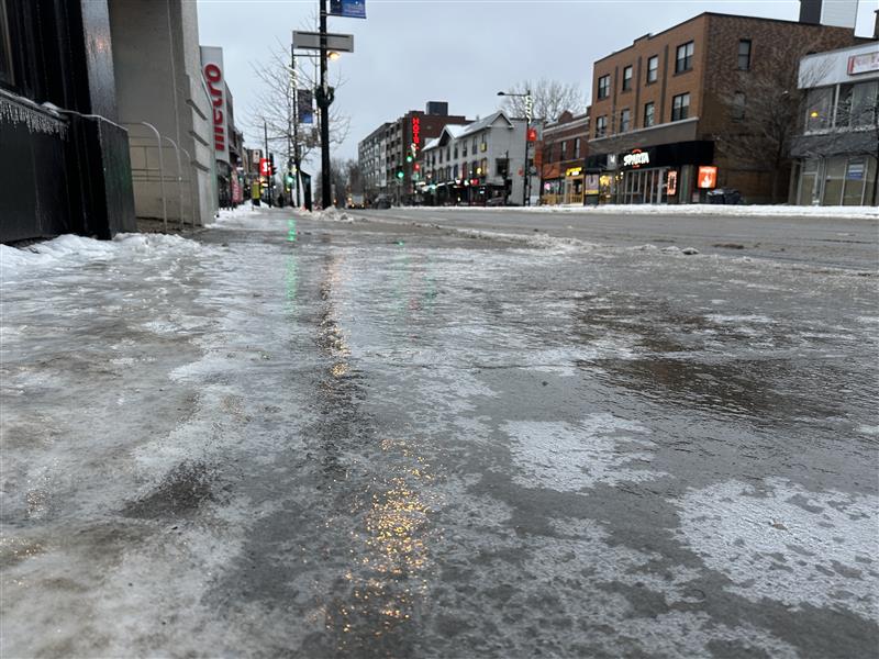
Montreal is facing a volatile stretch of winter weather today as freezing rain, strong winds and plunging temperatures trigger two weather alerts across the region.
A prolonged period of freezing rain and ice pellets is expected to continue through the end of the day, with 5 to 15 millimetres of ice accretion forecast for the Montreal area. Conditions will be especially treacherous this morning, with freezing rain gradually changing to snow mixed with rain later this afternoon. Temperatures will hover around plus 1 celsius , but the wind chill made it feel closer to minus -13 C early in the day.
Winds will intensify as the day progresses. Northeasterly winds this morning will shift to the southwest by late afternoon, reaching 60 km/h with gusts up to 90 km/h in Montreal.
Environment Canada warns that the combination of ice buildup and high winds could lead to falling branches, dangerous road conditions and prolonged power outages, particularly during the evening commute.
Tonight, skies will remain mostly cloudy with a 60 per cent chance of flurries. Temperatures are expected to drop sharply to minus – 12 C, with wind chills sinking from minus – 9 C in the evening to minus – 23 C overnight as strong winds continue.
Montreal mayor Soraya Martinez Ferrada took to social media to urge residents to stay cautious as the city deals with challenging weather.
Meteorologist Eric Tomlinson said the precipitation had largely shifted to regular rain by late morning in Montreal, but that freezing rain continued to fall north of the city. He warned that the temperature is expected to drop sharply during the night, which could once again turn surfaces slippery.
“We should see some improvement early this afternoon,” said Tomlinson. “It’ll get better over the next couple of hours, especially with treated roadways, conditions should improve. However, that being said, we do have a yellow wind warning out for the city of Montreal for this afternoon. And so with the passage of the cold front at around 3pm, winds will pick up quite significantly with gusts up to 90 kilometers an hour expected for the city of Montreal this afternoon and evening.”
Sharp rise in 911 calls in Montreal
A Montreal-area ambulance service reported receiving more than one hundred 911 calls per hour on Monday, as parts of Eastern Canada were hit by freezing rain, blowing snow and strong winds.
“Stay home unless you absolutely need to go out,” said Alexandre Sapone Chief of Operations, Management Control centre at Urgence-santé. “When you do have to get out, please try and wear the proper apparel, shoes, the proper spikes if possible also with the shoes.
Urgences-santé said most of the calls involved people who had fallen and hurt themselves, with ice coating roads and sidewalks. Spokesperson Valérie Guertin urged people to stay home if possible, and if they have to go outside, she advised them to wear crampons and adapt their driving to the weather.
“Ambulance requests (are) mostly for falls on the ice, traumatic injuries or people with injuries following a fall,” she said in a phone interview. Ambulance crews have been able so far to handle the level of calls, but they are asking people who witness a fall to call 911 only if they’re sure the person has been hurt, she added.
Much of southern and western Quebec were under weather alerts for prolonged periods of freezing rain with ice pellets that can make travel hazardous.
“If it’s possible, try and compose 811 and for any medical advice or anything, that’s gonna help our 911 system to be able to prioritize the right one,” said Sapone. “So if your life is not in danger, try and seek medical attention through 811 for questions and everything.”
Weather ahead
Tuesday will offer little relief, with mainly cloudy skies and flurries lingering throughout the day. The temperature will struggle to reach minus – 10 C, while brisk west winds keep the wind chill near minus – 23 C. Cloudy conditions and flurries continue Tuesday night, with a low of minus – 13 C.
Midweek brings colder but calmer conditions. Wednesday will see a mix of sun and cloud with a daytime high of minus – 10 C, followed by a cloudy night with temperatures falling to minus – 18 C. New Year’s Day will remain cold but brighter, with a mix of sun and cloud and a high of minus – 13 C, before clearing skies overnight send temperatures plunging to minus – 21 C.
Friday is expected to be sunny but frigid, with a high of minus – 12 C, while clouds return overnight and temperatures dip to minus – 15 C. The weekend remains unsettled, with a mix of sun and cloud Saturday and a high of minus – 11 C, followed by a cloudy night and a 60 per cent chance of flurries with a low of minus – 12 C. Sunday will stay cloudy with flurries possible and a slightly milder high of minus – 8 C.
“So, the good news in a way is that after the system moves through, we’re not expecting any other major winter weather systems until at least the weekend for the Montreal area,” said Tomlinson. “As of now, that’s what it looks like.”
Montrealers are urged to avoid unnecessary travel, allow extra time for commutes, and stay alert for falling ice and branches as the storm continues to unfold.
—With files from The Canadian Press